The best source of early natural history for the Black Belt (and Alabama, generally) is the collection of Philip Henry Gosse’s early writings from 1838. This book provides detailed descriptions of Gosse’s travels to the Black Belt and his penetrating observations. Gosse was a young English naturalist who appreciated the rich flora and fauna of Alabama more than most of its then-inhabitants, and his writings provide a fascinating eyewitness account of that early period of settlement and its peculiar ecology and human history. It is an indispensable resource for anyone interested in the natural history of Central an Southern Alabama.
Tennessee
“Tuesday 11 Breakfasted at Mrs. Shannons [near Lexington by the Tennessee River] as we were fearful of not getting anything as good on the road – which was the worst we had traveled – it was merely a footpath through the woods forking at every 3 or 4 miles – not a post or sign board to direct us, and we would be certainly on the lookout to see that we did not leave the one notched for that was our only guide…
…Mr. C[onner] was compelled to be on business several days in a wilderness part of the country where there was not a road cut for carriages and consequently I was obliged to remain here [in Jackson, TN].
Friday 14. Mr. C[onner] left me early for his journey in the wilderness for such it really is – I should perhaps be subject to much ridicule were I to express my ideas of my almost heroism in behaving with becoming dignity on the occassion..
Saturday 15…this section of the country has been so recently settled the town itself has not been located 5 yrs that the buildings are of course plain and many is in an unfurnished state – all articles of luxury or even what we consider necessaries are extravagantly high, owing to the expense and difficulty of importation – it is impossible for one who has not visited a new country to form any adequate idea of the difficulty and labor requisite to clear the land and form a decent habitation…
Sunday 16…Mr C[onner] most unexpectedly returned, ’twas indeed a most delightful surprise as I had not anticipated seeing him for two or three days – but he was fortunate in transacting his business and hurried his return as much as possible — he had a lonely ride through the woods and poor fare..
Tuesday 18. We took a friendly farewell of our hospitable friends and retraced our steps to Nashville [from Jackson to Huntingdon] the road was but indifferent the weather excessively warm having while on the prairies the full influence of the sun..”
From the Journal of Juliann Conner (1827)
Alabama
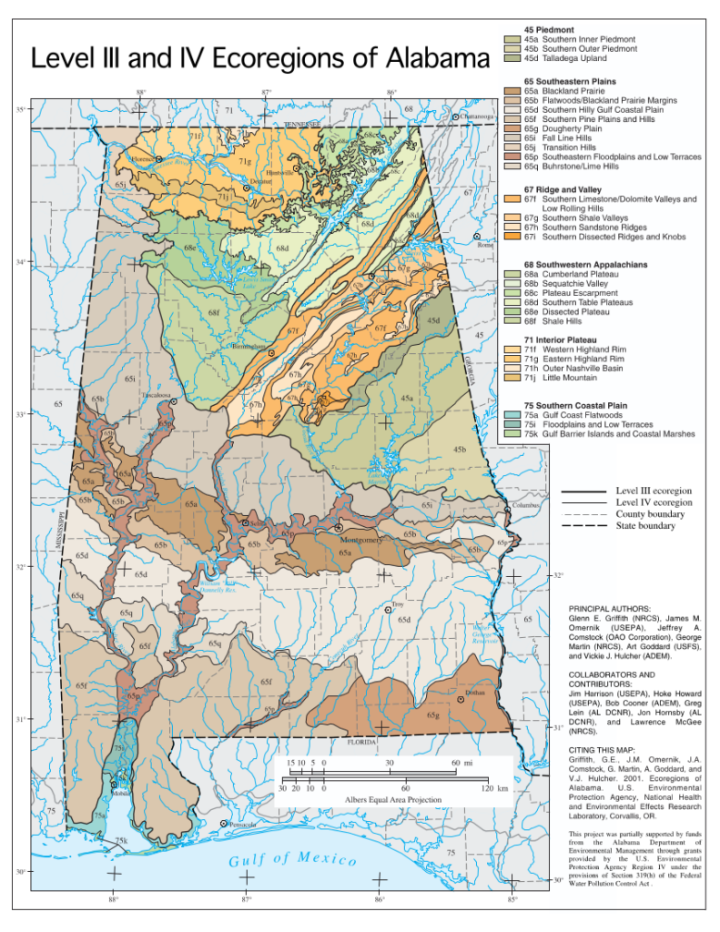
“Selma, as we have elsewhere stated, is about the centre of the great Southern cretaceous belt, that commences about Macon, Ga., sweeps around, including Columbus, Ga., Montgomery, Selma, Uniontown and Demopolis, passing through Western Tennessee, and terminating near the mouth of the Ohio river, and is the great cotton belt, including the celebrated cane brake and prairie lands. At no point, however, in this belt, has Artesian wells been so successfully bored as in Selma. These wells, some of them, contain salts of iron, in solution, sufficient to give a slight chalybeate taste, and on this account doubtless possess great tonic qualities.”
From Selma: her institutions and her men by John Hardy (1870), p. 150
ROLLING AND PRAIRIE LANDS.
These lands lie to the southwest of the mountain region with its valleys, as above described, or to the south and west of the broken line that connects the first cascades, or rocky obstructions to navigation in the different rivers, or along and to the south and west of the old shore line of the Gulf of Mexico, as has been defined by the State Geologist. They form a belt of country that runs, in a general way, diagonally across the State. This belt is some thirty miles wide next to the Mississippi line, but narrows towards the east, until it finally comes to a point near the Georgia line. It embraces some 5,915 square miles. These lands do not present any very striking topographical features, as they are comprised of strata of comparative uniformity in hardness, and of strata that are almost level, having only a slight dip to the southwest. These lands are, however, hilly and broken along their upper edge, or the old shore line, where they are cut up by some deep gullies and ravines, and hence have some considerable irregularities of surface. They form the prairie region that is known as the Black Belt, or Canebrake, and are, for the most part, of this region. This prairie region has a gently undulating surface, and a remarkable uniformity in its topography. It is in places covered by a fine forest growth of oak, ash, gum, hickory, etc., though, as a general thing, it is bare of such, and is in cultivation. It is noted for the great fertility and durability of its soils. It produced before the war more of agricultural value than any area of like extent in the United States. It may, some of these days, become worldwide famous for its phosphatic deposits.
From Northern Alabama Historical and Biographical Illustrated p. 10
“At that time [1832 or 1833] the ‘Canebrake’ in Marengo county was but little known. The water falling upon its surface was impeded in its flow by the cane and leaves and limbs which had fallen, and it was believed to be too wet for cotton.”
From Early Settlers of Alabama by Col. James Edmonds Saunders (1899), p. 264
“The arborescent grasses of the bamboo tribe, the so-called cane, represented in eastern North America by Arundinaria macrosperma and A, tecta, form by their spread over wide areas a most peculiar and prominent feature in the vegetation of the State, known as canebrakes. The big cane, attaining not rarely a height of from 20 to 30 feet, occupies the more or less overflowed alluvial river banks. The so-called reed or switch cane, of smaller size, forms the impenetrable undergrowth of the forests of the humid and fresh soil depressions, and is most prevalent in the Cretaceous plain [blackbelt], designated as the canebrake region.”
From the Plant Life of Alabama by Charles Mohr (1901), p 45
CENTRAL PRAIRIE REGION
PHYSIOGRAPHICAL FEATURES.
This floral region comprises the plain of Cretaceous rocks which crosses the State in a belt from 35 to 45 miles wide, its mean elevation above the Gulf of Mexico scarcely exceeding 200 feet. It is inclosed at its northern and at its southern limit between the pineclad hills, which rise from 150 to 250 feet above the depression of the plain. Rarely perfectly level, the plain rises in broad swells above the sluggish water courses. Westward the water courses of this plain are the tributaries of the Tombigbee and Alabama rivers, and toward the east they empty into the numerous bays which indent the coast of western Florida or into the Chattahoochee River. It covers an area roughly estimated to exceed somewhat 5,000 square miles, embracing all, or nearly all, of Greene, Hale, Dallas, Lowndes, Montgomery, Macon, and Bullock counties, and parts of Sumter, Marengo, Perry, Autauga, Pike, and Russell.
XEROPHILE FORESTS.
Post-oak prairies — All over the region, particularly on the highest swells, the drifted clayey loams, sands, and pebbles mingle with the soil resulting from the decomposition of the underlying limestone strata, and give rise to light, more or less sandy, loams or heavy calcareous clay soils, covered with open xerophile forests of Spanish oak [southern red oak] [Quercus falcata], black oak [Quercus velutina], black jack [Quercus marilandica], post oak [Quercus stellata], the last predominating, associates with mockernut [Carya tomentosa] and pignut hickory [Carya glabra]. Where the heavy clay soil prevail, destitute of humus, water-soaked during seasons of rain and baking to a hard crust during droughts, these so-called post oak prairies have been but little encroached upon. Under the cover of the brush the gramineous plant formations predominate, while sedge grasses (Cuperaceae) abound in the more shaded and wet situations. For example, Eleocharis tuberculosa [large-tubercled spikerush], E. ovata [a spikerush] and Cyperus pseudo-vegetus [green flatsedge], on the borders of ditches and pools; Carex triceps [Carex howei, Howe’s sedge] a very distinct southern type, occurring from South Carolina to central Texas, but not in this State north of the. southern edge of the metamorphic hills; C. hlrsuta [Carex hirsutella, hairy-leaved sedge], C. oblita [southern dark green sedge], C. sterilis [sterile sedge], C. lurida [sallow sedge], common throughout the Carolinian area; C. oxylepis [sharp-scaled sedge], C. cherokeensis [Cherokee sedge], C. debilis [white-edged sedge], C. pubera [Carex allegheniensis, Allegheny sedge] of a more southern range; together with Panicum melicarium, P. anceps [Coleataenia anceps, beaked panic grass] and Uniola laxa [Chasmanthium laxum, slender spikegrass]. In drier and more exposed places:
Scleria triglomerata (abundant) [tall nutrush], Steironema ciliatum [fringed loosestrife], Allium canadense [wild onion], Steironema lanceolatum [lanceleaf loosestrife], Quamasia esculenta [Camassia scilloides, wild hyacinth], Penstemon hirsutus [northeastern beardtongue], Lobelia appendiculata [pale lobelia], Hibiscus incanis [Hibiscus moscheutos, eastern rose-mallow]
The last is a stately perennial of the Louisianian area known from a few localities between South Carolina and northwestern Louisiana. The ubiquitous bush clovers, Japanese clover, and tick-trefoils in a large measure take possession of the drier and lighter soil in the post oak woods.
Where the limestone strata come near to the surface and the soil is not of sufficient depth to support a heavier tree growth, the oaks and hickories give way to copses of small trees and shrubs, among which hawthorns of different species are most abundant. Characteristic spocies are:
Crataegus coccinea (scarlet haw.), Prunus umbellata (prairie plum [hog plum]), Crataegus molle [Crataegus mollis?] (black thorn), Bumelia lycioides (false southern buck-thorn), Crataegus crus-galli (cockspur thorn), Crataegus flava (summer haw.), Rhamnus caroliniana [Frangula caroliniana] (Carolina buck-thorn), Crataegus viridis (red haw.), Pyrus angustifolia [Malus angustifolia] (southern crab apple). Ptelea trifoliata (trefoil hop tree).
These coppices form isolated boskets in the open or skirt the postoak prairies, and when covered in the spring with the snowy white flowers of hawthorns, plums, and crab apples or adorned in autumn with their lurid red and flaming scarlet fruits, impart to the landscape a peculiar charm, relieving the monotony of the interminable fields of cotton.
Hill prairies. — On the hills bordering the plain northward and southward and on the highest ridges within the plain, capped like the hills with drifted siliceous deposits, the short-leaf pine [Pinus echinata] mingles with the hard-wood trees, while the longleaf pine [Pinus palustris] makes its appearance on the most abrupt of their summits. Where on these hills the drifted soils have been removed by denudation, the rich black soil of the prairies or calcareous marls prevails, covered either with the white oaks [Quercus spp.] and hickories [Carya spp.], or with cedar hammocks [Juniperus virginiana]. These so-called hill prairies are mostly under cultivation, and the abandoned exhausted fields have been taken possession of by shortleaf [Pinus echinata] and loblolly pine [Pinus taeda]. East of the Alabama River, particularly on the divide between the waters of the Tallapoosa and those of the tributaries of the Chattahoochee, Choctawhatchee, and Conecuh rivers, the plain becomes broken into low hills, and the drifted deposits mingle largely with the soils of the rotten limestone. On these hills the timber growth, through the frequent interspersion of the shortleaf pine, assumes the same mixed character which prevails in the adjoining upper division of the Maritime pine belt.
In the ravines and the narrow valleys the Southern spruce pine (Pinus glabra) with magnolias and cucumber trees [Magnolia acuminata] is of frequent occurrence.
MESOPHILE FORESTS.
Prairie region. — The term “prairie region,” applied to this plain, refers less to the timberless tracts which originally formed a small fraction of its area than to the black, calcareous, highly fertile soil of these uplands, which, being rich in humus, as a result of the reaction of its calcareous constituents upon vegetable matter, closely resembles the equally productive soil of the western treeless prairies. Before its settlement by whites this region was largely covered by forests of a decidedly mesophile character, mostly of hardwood trees, in some localities mixed with red cedar [Juniperus virginiana]. On the fertile uplands the forest has been almost entirely removed; the bottoms of the Alabama and Tombigbee rivers and their largest tributaries, where subject to overflow, are still heavily timbered with a mesophile growth of cow oak [swamp chestnut oak, Quercus michauxii], overcup oak (Quercus lyrata), laurel oak (Quercus larifolia), water oak [Quercus nigra], red or sweet gum [Liquidambar styraciflua] — in such perfection as this tree attains only in the Atlantic forests of the lower latitudes — beech [Fagus grandifolia], mockernut (Hicoria alba) [Carya tomentosa] and bitternut hickory (Hicoria minima) [Carya glabra], all draped with Spanish moss. A fine elm [Ulmus] is also frequently met with here of a sturdy growth, often fully 2 feet in diameter, the branchlets covered with corky flat expansions of the bark. Although not seen in flower or fruit this tree certainly is distinct from the white elm (Ulmus americana) and is doubtless identical with the Southern white elm [Ulmus serotina, September elm] lately discovered by Messrs. Sargent and Canby near Huntsville, and described in the succeeding catalogue. With the rise of the land above overflow tulip trees [Liriodendron tulipifera], linden [Tilia], mulberry [Morus rubra], stately magnolias, hackberry [Celtis], and red bay (Persea borbonica) mingle with the trees of the bottom. The diversity of the arboreal vegetation increases further on the broad swells of the uplands with a rich dark soil, as is apparent from the rather scanty remains of their tree covering observed between Uniontown and Demopolis. On these rich uplands the Texas white oak (Quereus breviloba) [Quercus sinuata var. breviloba, Bigelow oak], commonly known in this section as pin oak, is found most frequent and in the same perfection as in the rich bottom lands of southern Texas, rivaling in size the common white oak [Quercus alba]. This beautiful oak is at once recognized by the diverse shapes of the leaves, which frequently vary on the same tree from oblong-lanceolate and entire to broadly ovate or obovate and obtusely three-lobed at the apex; and also by the small fruit. The post oak [Quercus stellata], in its best-developed state, is frequently associated with the above. Black walnut [Juglans nigra], frequently mentioned in the record of earlier times, is at present extremely scarce; in fact, as a timber tree it has disappeared from these forests. The pecan (Hicoria pecan) [Carya illinoinensis] and nutmeg hickory (Hicoria myrsticaeformis) [Carya myristiciformis] are frequently scattered among the oaks throughout the woodlands of this region in the basin of the Alabama and Tombigbee rivers. There can be no doubt about the pecan being indigenous to this region, although heretofore not regarded as a native of the eastern Gulf region outside of the Mississippi and Yazoo deltas. Groves of full-grown trees, which must have been in existence before the arrival of the first white settlers, are remembered by very old inhabitants. A few of these landmarks of the original forest growth still survive, surrounded by their offspring of succeeding generations, notably on a plantation near Faunsdale, Dallas County. Generally this tree has disappeared with the oak forest on the fertile lands, and is at present found only in the small groves of oaks saved from destruction to shade the grounds around the dwellings of the planters. The nutmeg hickory [Carya myristiciformis], when full grown, resembles the shagbark hickory in its pale, shreddy bark, but it is readily distinguished from the latter by the silvery hue of the lower surface of the leaves and the smaller fruit, with a thin epicarp inclosing the perfectly smooth nut, which simulates the nutmeg in size and shape. By the discovery of the nutmeg hickory in this region, and of its extension into Mississippi, the northern limit of the distribution of this tree from the Atlantic slope in South Carolina to Texas and northern Mexico, following with hardly any deviation, the same parallel of latitude, is now clearly established.
Of trees of smaller size the pawpaw (Asimina triloba), redbud (Cercis canadensis), Carolina buckthorn (Rhamnus caroliniana) [Frangula caroliniana], and of shrubs the spice bush (Benzoin laurus) benzoin) [Lindera benzoin], form the undergrowth and frequent the openings. Vitis aestivalis, the vigorous summer grape, Vitis cinerea [pigeon grape], Vitis rotundifolia [muscadine], the slender-stemmed bullace grape, and the supple jack (Berchemia volubilis) [Berchemia scandens], ascend the highest trees without visible support below the lofty summits, where these members of the liana formation spread out their branches, and under a fuller exposure to the sun unfold their flowers and ripen their fruit. With these are associated a number of others of the same plant formation, namely:
Bignonia crucigera [Bignonia capreolata] (cross vine) . Ampelopsis arborea [Nekemias arborea] (Vitis bipinnata Torr. pepperidge vine [pepper vine]), Parthenocissus quinquefolia (Virginia creeper), Ampelopsis cordata [heartleaf peppervine], Tecoma radicans [Campsis radicans] (trumpet vine) .
These vigorous woody climbers cover with their festoons the borders of these forests as it were with an impenetrable curtain of green. Smaller woody and herbaceous perennial climbers entangling the bushes and smaller trees are:
Smilax bana-nox (greenbrier) [catbriar], Cebatha carolina [Nephroia carolina, snailseed], Smiiax laurifolia (greenbrier) [laurel-leaf greenbriar], Aristolochia tomentosa [wooly dutchman’s-pipe], Smilax lanceolata [Smilax smallii] (greenbrier) [jacksonbriar], Calycocarpum lyonii (cup vine), Brunnichia cirrhosa [Brunnichia ovata, eardrop-vine], Schizandra coccinea [Schisandra glabra, climbing-magnolia].
The last is a type of the Louisianian area, sparsely distributed from South Carolina to northwestern Louisiana. Nowhere is the poison ivy (Rhus radicans) [Toxicodendron radicans] found of more luxuriant growth and in greater abundance than in the openings of the damp forests. Taking a firm hold in the bark of trees with its innumerable rootlets, the stem creeps up to the top of the highest tininks, which are completely hidden by the long horizontal branches of this creeper when covered with their soft, rich foliage.
Cedar hammocks. — On the highest swells of the plain where the strata of the rotten limestone are overlaid by lighter loams poorer in humus, deep, and of perfect drainage, forests prevail of a mixed-tree growth, consisting of the following:
Fraxinus americana (white ash), Ulmus americana (white elm) [American elm], Quercus laurifolia (laurel oak), Acer saccharum barbatum (small-leaf sugar maple) [southern sugar maple], Celtis mississippiensis [Celtis laevigata] (hackberry) [sugarberry], Quercus texana [Quercus falcata] (Southern red oak), Juniperus virginiana (red cedar) .
Originally the red cedar formed about 30 per cent of the timber growth. The ground beneath is densely shaded by the following:
Asimina triloba (pawpaw), Zanthoxylum clava-herculis (Southern prickly ash), Ilex decidua (deciduous holly), Adelia ligustrina [Forestiera ligustrina] (Southern privet) [glade privet].
The red cedar of these forests is of most vigorous growth, the smooth trunk free of limb for a height of from 30 to 50 feet and from 16 to 20 inches and over in diameter, and less affected by decay than in the northern part of the State. These cedar hammocks once formed detached tracts extending over many square miles. At present only a few remnants of them are left, and these are doomed to speedy destruction by the drafts made upon their valuable timber and through the injuries constantly inflicted upon the young growth by live stock.
MES0PHILE HERBACEOUS PLANT ASSOCIATIONS.
In the shade of these forests, as observed on the banks of Big Prairie Creek, the herbaceous plant associations are poorly represented by mesophile species more or less common throughout the Carolinian area. Some of the species are:
Adicea urticaefoiia, Vincetoxicum laeve, Impatiens biftora [Impatiens capensis, jewelweeed], Trepocarpus aethusae [white nymph], Thaspium aureum [Thaspium trifoliatum var aureum, yellow meadow-parsnip], Dioclea multiflora [Lackea multiflora, clusterpea], Vincetoxicum (Gonolobus) hirsutum
The Trepocarpus is frequent in eastern Texas, but has heretofore been known in the eastern Gulf States only as a fugitive on ballast in several localities. The Dloclea has been known from a few localities in Georgia, and especially along the Luxapallila River, near Columbus, Miss., and is abundant in the bottoms of the Mississippi and Yazoo deltas.
Canebrakes. — The most prominent feature in the vegetation of this region consists of the extensive tracts of cane, arborescent grasses of the bamboo tribe, which prevail throughout the depression of the plain. The large cane (Arundinaria macrosperma) [Arundinaria gigantea] inhabits the alluvial bottoms more or less submerged for the greater part of the year, and the small or switch cane (A. tecta) prevails in the open as well as in the forest on the low plains which rise above the water courses and are subject to overflow only at the time of high freshets. So conspicuous was this formation in the western part of the plain that it is called emphatically the ”cane brake region.” At present a comparatively small representation of the smaller cane remains. It occupied the most fertile lands, and these were claimed for the plow by the earliest settlers. Although the growth was so dense as to be almost impenetrable, it was easily eradicated, being susceptible to the effects of fire. The strips of the large cane which lined the banks of the larger streams subject to frequent overflow have for the most part remained intact. These two species, which resemble each other so closely in habit, differ greatly in their modes of reproduction, a subject of much interest of which but little is as yet known and one which invites the attention of the investigator of the ecological relations of plants, and no less that of the agriculturist, on account of the value of the canes as pasture plants. Arundinaria tecta [switch cane] rarely exceeds the height of 12 to 15 feet, and the slender culm branched from the base is seldom half an inch in thickness. Early in spring, apparently every three or four years, the paniculate flowers are produced on naked radical shoots scarcely exceeding 18 inches in height, while the tall flowerless canes are sent up every season from the long creeping rhizomes. Arundinaria macrosperma [A. gigantea] from 15 to 30 feet high and frequently an inch and over in diameter, produces the panicles of its flowers in the axils of the branches at long and indefinite intervals of time. It is evident, therefore, that generations may pass. by before the spectacle of such a canebrake in bloom is ever witnessed. For example, in the beginning of the summer of 1896 the inhabitants of Russell County were astonished suddenly to find the large canebrakes bending under the burden of their heavy, nutritious grains, which attracted large numbers of birds and beasts. The farmers regarded this as an entirely new plant, and, finding their stock grew fat upon the seed, stored away quantities of it, not only for future feeding, but under the delusion that if sown it would constitute a crop of small grain equal in value to any previously grown. But in the light of experience it is to be presiuned that a period of not less than forty to fifty years has to pass before the propagation of this plant by sexual reproduction takes place. With the maturity of the seed the vitality of the plant is exhausted and the cane decays. In the succeeding season, from the spontaneous stocking of the ground with an abundance of seed, a new crop springs up. The seedlings produce no branches during the first year. These simple sprouts, which are known as “mutton cane,” are tender and sweet and afford the best of pasturage. They are particularly sought after by bears, which find in the impenetrable density of the canebrake their securest retreats.
CAMPESTRIAN PLANT ASSOCIATIONS
Bald prairies. — The eminences of the lower swells of the plain with the strata of the limestone near the surface and destitute of arboreal growth are called bald prairies. Wherever the soil is not too shallow to be cultivated, these open prairie lands are devoted to the production of corn, oats, or forage crops, and only the poorest spots remain in the original state. These bald prairies can be regarded as the true home of the original campestrian flora, which is peculiar to a calcareous soil rich in humus and with a sunny exposure. Many of its types are held in common with the plant associations prevalent on the grassy timberless plains of eastern North America. These types have spread all over the cretaceous depression wherever the forest has been removed, and find refuge also on the borders of fields and woods, and in waste places and abandoned grounds. Of grasses the following are most common in the open, except the last two, which prefer sheltered borders:
Paspalum laeve, Eragrostis capillaris [lace lovegrass], Paspalum distichum [joint paspalum], Eragrostis refracta [coastal lovegrass], Panicum flexile [wiry panicgrass], Eragrostis purshii [Eragrostis pectinacea, Carolina lovegrass], Panicum autumnale, Poa compressa [^flat-stemmed bluegrass, maybe native], Andropogon furcatus [Andropogon gerardii, big bluestem], Elymus virginicus [common eastern wild-rye], Sieglingia seslerioides [Tridens flavus, tall redtop], Bromus unioloides [*Bromus catharticus, rescue grass, nonnative], Bouteloua curtipendula [side-oats grama], Uniola latifolia [Chasmanthium latifolium, river oats]
…Associated with the grasses are the following species widely distributed in the open of the Carolinian area:
Hypericum sphaerocarpum [barrens St. John’s-wort], Verbena angustifolia [Verbena simplex, narrowleaf vervain], Kuhnistera candida [Dalea candida, white prairie-clover], Verbena canadensis ( V. aubletia) [Glandularia canadensis, rose vervain], Kuhnistera purpurea [Dalea purpurea, purple prairie-clover], Eupatorium altissimum (rare) [Ageratina altissima, common white snakeroot], Acuan illinoensis [Desmanthus illinoinensis, common bundleflower], Eupatorium serotinum [late thoroughwort], Cassia multipinnata [Chamaecrista nictitans, common sensitive-plant], Silphium laciniatum [compass-plant], Polygala mariana [Senega mariana, Maryland milkwort], Silphium scaberrimum [Silphium asteriscus var. asteriscus, rosinweed], Linum sulcatum [grooved yellow flax], Silphium trifoliatum [Silphium asteriscus var. trifoliatum, rosinweed], Euphorbia dictyosperma [Euphorbia spathulata, prairie spurge], Brauneria pallida [Echinacea pallida, pale purple coneflower], Onagra biennis [Oenothera biennis, common evening-primrose], Rudbeckia trilobata [Rudbeckia triloba, common three-lobed coneflower], Gaura michauxii [Oenothera filipes, threadstalk gaura], Helianthus hirsutus [hairy sunflower], Polytaenia nuttallii [prairie parsley], Helianthus divaricatus [woodland sunflower], Asclepias obovata [pineland milkweed], Coreopsis lanceolata [longstalk coreopsis], Asclepiodora viridis [Asclepias viridis, green antelope-horn], Lepachys pinnata, Heliotropium tenellum [Euploca tenella, delicate heliotrope], Mesadenia plantaginifolia [Arnoglossum plantagineum, western indian-plantain], Myosotis vema [early forget-me-not].
Of other herbaceous plants belonging to the same campestrian association and confined to the Louisianian area are to be mentioned Polygala boykinii [Senega boykinii, Boykin’s milkwort] and Xylopleurum speciosum, conspicuous on account of their large flowers of bright rose color, common on the prairies of central Texas, southern Arkansas, and northwestern Louisiana and appearing to be indigenous in Alabama, and Gaillardia pulchella [common blanketflower], Rudbeckia amplexicaulis [Dracopis amplexicaulis, clasping coneflower] and Monarda citriodora [lemon bergamot], of the same distribution but less frequent here, and perhaps adventive by the seed having come with the seed oats frequently brought from central Texas.
Sand hills near Montgomery. — A peculiar association of xerophile herbs, remarkable for the occurrence of types not observed elsewhere in the State, is found on the hills with a loamy, sandy soil, rising above the cypress swamps on the eastern banks of the Alabama River near the city of Montgomery. At the base of the hills occur:
Carduus elliottii [Cirsium horridulum, common yellow thistle], Isopappus divaricatus [Croptilon divaricatum, scratch-daisy], Cnicus benedictus (naturalized from Europe) [*Centaurea benedicta, nonnative], Tragia urticaefolia [nettleleaf noseburn],
The sides of the hills are covered with xerophile grasses:
Aristida dichotoma [fork-tip three-awn], Panicum cognatum [Leptoloma cognatum, fall witchgrass], Eragrostis capillaris [lace lovegrass], Panicam flexile [wiry panicgrass], Eragrostis refracta [coastal lovegrass]
The grass is studded with:
Aster undulatus [Symphyotrichum undulatum, wavyleaf aster], Allionia hirsuta [Mirabilis albida, wild four-o’clock], Aster patens [Symphyotrichum patens, common clasping aster], Silene ovata [mountain catchfly], Kuhnia eupatorioides [Brickellia eupatoroides, eastern Kuhnia].
The northern Kuhnia [Brickellia eupatoroides] is extremely rare in the State. Allionia hirsuta [Mirabilis albida, wild four-o’clock] is at home in the prairies of the West from Minnesota to Texas. Silene ovata [mountain catchfly] is found in the exposed ravines of these hills. It is also found in the Cumberland highlands of Tennessee, and is distributed somewhat widely in the mountains- of the Carolinas and Georgia.
From the Plant Life of Alabama by Charles Mohr (1901), pp 97-105
Mississippi
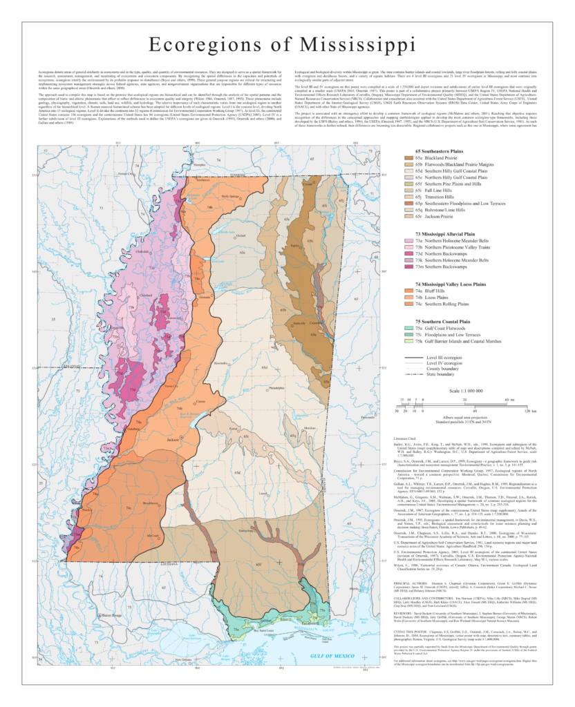
Northeastern Prairie Belt.—The boundaries of this region and its relationship to other divisions can best be understood by reference to the sketch map referred to above.
The region has a gently rolling surface, and was originally prairies, having only here and there scattered patches of trees, except on the stream bottoms, which supported heavy growths of timber. This Prairie Belt is now largely in cultivation, but some timber remains in the bottoms. Within the last several years lands formerly in cultivation and now thrown out, show a strong tendency to grow up in trees, in some places the old field pine [Pinus taeda, loblolly pine], in others thickets of shrubby oaks [Quercus spp.].
The characteristic soil of the prairies, which is residual from the Cretaceous limestone, is a heavy, tenaceous, calcareous loamy clay, dark gray when dry, but almost black when wet. In much of the region a yellowish-brown loam soil prevails. This is a lighter soil than the typical prairie soil, less fertile, and usually supports a tree growth chiefly of post oak [Quercus stellata], black jack [Quercus marilandica], and Spanish oak [Quercus falcata, southern red oak]. The dark soil is the typical soil of the region and is naturally devoid of trees, except scattered clumps of crab apple [Malus spp.], hackberry [Celtis spp.], and red cedar [Juniperus virginiana], with deciduous holly [Ilex decidua] and honey locust [Gleditsia triacanthos] in low depressions.
On the open prairies characteristic and showy species of herbaceous plants are the following:
Coreopsis lanceolata [lanceleaf coreopsis], Coreopsis grandiflora [large-flowered coreopsis], Silphium laciniatum, Silphium terebinthinaceum [compass-plant], *Melilotus alba [*non-native, invasive], *Hartmannnia speciosa [Oenothera speciosa, showy evening-primrose, *non-native], Lythrum alatum [northern winged loosestrife], Cacalia tuberosa [Arnoglossum plantagineum, western indian-plantain], Oenothera triloba [stemless evening-primrose], Asclepiodora viridis [Asclepias viridis, green antelope-horn], Asclepias tuberosa [monarch’s-delight], Asclepias verticillata [whorled milkweed], Rudbeckia hirta [black-eyed susan], Rudbeckia laciniata [cutleaf coneflower], Sisyrinchium albidum [white blue-eyed grass], Liatris graminifolia [Liatris pilosa, grass-leaved gayfeather], Petalostemon carneus [Dalea carnea, pink-tassels], Petalostemon corymbosus [Dalea pinnata var. trifoliata, eastern prairie clover], Otophylla Michauxii [Agalinis auriculata, earleaf foxglove],
Otophylla [Agalinis] has been found in the priaries near Scooba, where it is frequent. Oenothera triloba [stemless evening-primrose], with large handsome lemon-colored flowers, is common around Okolona, especially in open lowland pastures along creeks.
Most of the others mentioned in the above list are very characteristic prairie species and widely distributed over the limestone soils. Hartmannia [Oenother speciosa] often occurs thickly covering areas that are acres in extent, and in the spring the large pinkish flowers densely massed form a handsome and striking covering to the gently undulating prairie surface.
On the lighter and usually higher reddish soil areas which dot the prairie surface like islands, an entirely different assemblage oceurs. This soil is not so rich in plant food as the black soils, lime especially being in much smaller proportions. These areas support a rather dwarfish growth of a few species of trees, chiefly oaks, the commonest being:
Quercus minor [Quercus stellata, post oak], Hicoria Alba [Carya tomentosa, mockernut hickory], Quercus Marilandica [blackjack oak], Diospyros Virginiana [American persimmon], Quercus digitata [Quercus falcata, southern red oak], Pinus echinata [shortleaf pine], Quereus velutina [black oak], Prunus serotina [black cherry], Quereus Durandi [Durand’s oak]
Characteristic herbaceous species associated with these are:
Rosa humilis [Rosa carolina, Carolina rose], Phlox pilosa [downy phlox], Tradescantia Virginica [Virginia spiderwort], Psoralea melilotoides [Orbexilum psoralioides, eastern sampson’s-snakeroot], Tephrosia Virginiana [Tephrosia virginiana, Virginia goat’s-rue], Spigelia Marilandica [Indian-pink], Plantago aristata (open ground) [buckhorn plantain], Verbena hastata [common vervain], Oenothera sinuata [Oenothera laciniata, cutleaf evening-primrose], Apocynum cannabinum [hemp dogbane].
The red sandy hills found occasionally in the prairie region, present still another assemblage of plants, the group as a whole resembling very closely the flora of the sandy loam regions of the North Central Plateau. The characteristic trees and shrubs are the following:
Liquidamber styraciflua [sweet gum], Diospyros virginiana [American persimmon], Sassafras officinale [Sassafras albidum, sassafras], Ulmus alata [winged elm], Rhus glabra [smooth sumac], Rhus typhina [staghorn sumac], Quercus Marilandica [blackjack oak], Vaccinium arborem [farkleberry], Tecoma radicans [Campsis radicans, trumpet creeper], Vitis rotundifolia [muscadine]
Hardly less characteristic is the herbaceous growth:
Ceanothus Americana [C. americanus, New Jersey tea], Pentstemon laevigatus [eastern smooth beardtongue], Phox pilosa [downy phlox], Specularia perfoliata [Triodanis perfoliata, Venus’ looking-glass], Opuntia sp. [prickly-pear], Aster paludosus [Eurybia paludosa, Savanna grass-leaved aster], *Trifolium procumbens [*T. campestre, *non-native], Krigia Virginica [Virginia dwarf-dandelion], Plantago aristata [buckhorn plantain], Gnaphalium purpureum [Gamochaeta purpurea, spoonleaf purple-everlasting], Shrankia sp. [Mimosa sp., sensitive-briar], Stylosanthes elatior [Stylosanthes biflora, pencil-flower]
The soils on the stream bottoms are generally heavy and rich, with considerable lime. are:
Quercus velutina [black oak], Quercus alba [white oak], Quercus Durandi [Durand’s oak], Quercus nigra [water oak], Quercus Michauxii [swamp chestnut oak], Hicoria alba [Carya tomentosa, mockernut hickory], Gleditsia triacanthos [honey locust], Cissus bipinnata [Nekemias arborea, peppervine]
The common trees and shrubs
Liriodendron tulipifera [tulip-poplar], Morus rubra [red mulberry], Negundo aceroides [Acer negundo, boxelder maple], Fraxinus Americanus [white ash], Acer saccharum [sugar maple], Acer dasyecarpum [Acer saccharinum, silver maple], Cornus aspera, Ulmus fulva [Ulmus rubra, slippery elm], Lonicera sempervirens [coral honeysuckle], Asimina triloba [pawpaw], Brunnichia cirrhosa [Brunnichia ovata, buckwheat vine], Aesculus glabra [Ohio buckeye], Kraunia frutescens [Wisteria frutescens, American wisteria]
Common herbaceous forms over the river bottoms are:
Clematis crispa [southern leatherflower], Osmunda cinnamomea [Osmundastrum cinnamomeum, cinnamon fern], Arisaema quinatum [southern jack-in-the-pulpit], Dioscorea villosa [wild yam], Phlox divaricata [eastern blue phlox], Ilysanthes gratioloides [Lindernia dubia, yellowseed false-pimpernel], Ranunculus nitida [R. abortivus or R. septentrionalis], Viola cucullata [blue marsh-violet], Polymnia uvedalia [Smallanthus uvedalius, bearsfoot]
From Plants of Mississippi by E. N. Lowe (1921), pp. 32-35
Jackson Prairie Region.—This region of small prairies extends in a belt varying from 10 to 30 miles miles wide, in a directicn slightly northwest and southeast across the state (boundaries may be seen on the sketch map). Its greatest breadth is in the extreme western part from the longitude of Jackson to the Bluff Hills; eastward it narrows to the Alabama line. The region is one of rolling topography. In parts, as in the southern half of Madiscn County and the northern part of Hinds, the surface is gently rolling; in other parts where the soil is sandy, the topography is more broken. In the broad western part of the area the surface soil is Brown Loam of loess origin modified somewhat by the underlying calcareous Jackson clays; the sandy, hilly parts have a soil derived from the overlapping cf the Jackson clays by red and yellowish sands of the Pliocene beds.
The typical prairie soils are rather heavy dark gray, or, in much of the area, lighter gray clays produced by the weathering of the calcareous clays and marls of the Jackson formation. This character of soil is not found in continuity over wide spaces, but is generally patchy, the patches being surrounded by one of the other types.
As would be expected, the flora of the region presents three rather well-marked phases. The typical soil, that of the true prairie type, supports a characteristic prairie flora; the westtern loam part supports the flora of the Brown Loam region, modified by invasions from the prairie flora, and the sandy loam parts toward the southeast support the extensions of the flora of the southern long-leaf pine belt, modified by additions from the prairie flora.
In this brief sketch it will be necessary to notice only the flora of the typical prairie, since the flora of the adjacent Brown Loam region, already considered, gives a representative impression of the vegetation of that part of the region overlain by the Brown Loam. The sandy soil division is sufficiently lke the region lying immediately south that a discussion of the one will bring out the salient characteristics of both.
Most of the surface of even the prairie soil is now or has been, occupied by a somewhat undersized tree growth, in places quite open, in others rather dense. Further, while the trees in the western part are mostly hardwoods of a few species, in the more eastern parts pine, both long-leaf [Pinus palustris] and short-leaf [Pinus echinata], is the dominant tree, affording commercial stands. These are probably invasions, the long-leaf pine [Pinus palustris] coming from the sand regions to the south, and shortleaf pine [Pinus echinata] from the sandy hills to the north of the prairie region. That the pine is normally not a tree of the loess soil is evident, though it invades that region as a second growth. Practicallly all the commercial pine of the state lies east of the Loess and Brown Loam regions.
The trees growing chiefly in the western loam part of the prairie region are hardwoods, consisting of oaks [Quercus] of a few species, as post oak [Quercus stellata], black jack [Quercus marilandica], Spanish oak [Quercus falcata, southern red oak], tan-bark oak [Quercus prinus, chestnut oak], and Texas oak [Quercus texana, Nuttall oak]. With these, occasional hickories [Carya spp.], persimmon [Diospyros virginiana], and cedar [Juniperus virginiana] occur. Along with the pines in the more eastern parts black jack [Q. marilandica] and post oak [Q. stellata] are common, and occasionally the turkey oak [Quercus laevis] extends into the sandy ridges.
Some characteristic herbaceous species of the prairies proper are given below:
Rhus copallina [R. copallinum, winged sumac], Penstemon pubescens [P. multiflorus], Rhus glabra [smooth sumac], Petalostemon candidus [Dalea candida, white prairie-clover], Tephrosia spicata [spiked hoarypea], Petalostemon violaceus [Dalea purpurea, purple prairie-clover], Rhynchosia tomentosa [erect snoutbean], Baptisia leucantha [B. lactea], Delphineum azureum [D. carolininanum, Carolina larkspur], Silphium integrifolium [prairie rosinweed], Linum Virginianum [Virginia yellow-flax], Silphium scaberrimum [S. asteriscus var. asteriscus], Aesculus pavia [red buckeye], Liatris spicata [gayfeather], Polygala Boykinii [Senega boykinii, Boykin’s milkwort], Aster virgatus [Hydrophyllum virginianum, Virginia waterleaf], Desmanthus luteus [Neptunia lutea, yellow Neptunia], Rudbeckia hirta [woodland black-eyed susan], Desmanthus brachylobus [D. illinoensis, Illinois bundleflower], Rudbeckia triloba [three-lobed coneflower], Echinacea purpurea [purple coneflower], Rudbeckia laciniata [cutleaf coneflower], Solidago rugosa [wrinkle-leaf goldenrod], Buchnera elongata [Buchnera floridana, savanna bluehearts], Onosmodium Carolinianum [Lithospermum molle, Tennessee marbleseed], Cacalia tuberosa [Arnoglossum plantagineum, western Indian-plantain], Helenium angustifolium [?], Crotalaria Purshii [Coastal Plain rattlebox], Helianthus laetiflorus, Agave Virginica [Virginia false-aloe], Collinsonia scabriuscula [richweed], Asclepias variegata [redring milkweed], Acerates paniculata (Asclepiodora viridis) [Asclepias viridis, green-antelope-horn], Asclepias tuberosa [monarch’s-delight]
Lowland forms will not be described, as they present no characteristics different. from the lowlands of adjacent regions, in connection with which they are sufficiently discussed.
From Plants of Mississippi by E. N. Lowe (1921), pp. 47-49